 Catalogo de metadatos del IGME
Igneous rocks
Type of resources
Available actions
Topics
Keywords
Contact for the resource
Provided by
Formats
Representation types
Update frequencies
status
Scale
-
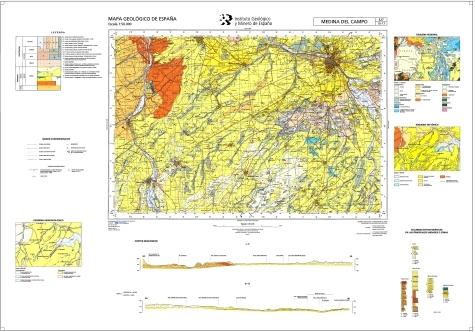
The sheet 427 (MEDINA DEL CAMPO) of the National Geological Map (MAGNA), was made in 2007 and published in 2014 by the Geological Survey of Spain. It is distributed at scale 50000. The geological map shows the nature of materials (rocks and sediments) that appear on the surface, their spatial distribution and geometric relationships between the different cartographic units represented. A geological mapping unit is the grouping of one or more lithologies with common age range, which is represented on the map at a scale or defined resolution. Each mapping unit, and the different geological structures, is represented on the map with a symbolism itself. The representation of these units on the topographic base map provides some three-dimensional information that is completed with other geological data and geological sections, stratigraphic profiles, polls, etc. The map legend is a pictogram representing the spatial relationship of the different mapping units (chronology, overlapping, geometric relationship, lateral facies changes, etc.). It also includes structural, hydrogeological and geological location of the sheet within the regional schemes. Since 1991, the Geological Map Series MAGNA is made inseparably with the geomorphological map on the same scale. This map incorporates everything on the surface geology and provides a structured and accurate information of the land forms. It is organized on the basis of morphogenesis and morphocronology incorporated the map using the corresponding chronostratigraphic column included in a table / legend inspired by the geological map. The forms, erosional and depositional, are represented on the map by individualized by symbols and patterns of color and surface deposits or lithological formations elements that provide information. For each sheet of the series MAGNA there is an explanatory report published, edited and in digital format. The digital information is stored in coverage and Shape format (ESRI). There is a guide that describes the physical structure of the digital information and its codification.
-
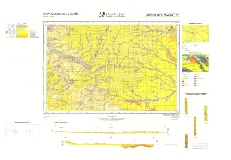
The sheet 407 (MORÓN DE ALMAZÁN) of the National Geological Map (MAGNA), was made in 1991 and published in 1994 by the Geological Survey of Spain. It is distributed at scale 50000. The geological map shows the nature of materials (rocks and sediments) that appear on the surface, their spatial distribution and geometric relationships between the different cartographic units represented. A geological mapping unit is the grouping of one or more lithologies with common age range, which is represented on the map at a scale or defined resolution. Each mapping unit, and the different geological structures, is represented on the map with a symbolism itself. The representation of these units on the topographic base map provides some three-dimensional information that is completed with other geological data and geological sections, stratigraphic profiles, polls, etc. The map legend is a pictogram representing the spatial relationship of the different mapping units (chronology, overlapping, geometric relationship, lateral facies changes, etc.). It also includes structural, hydrogeological and geological location of the sheet within the regional schemes. Since 1991, the Geological Map Series MAGNA is made inseparably with the geomorphological map on the same scale. This map incorporates everything on the surface geology and provides a structured and accurate information of the land forms. It is organized on the basis of morphogenesis and morphocronology incorporated the map using the corresponding chronostratigraphic column included in a table / legend inspired by the geological map. The forms, erosional and depositional, are represented on the map by individualized by symbols and patterns of color and surface deposits or lithological formations elements that provide information. For each sheet of the series MAGNA there is an explanatory report published, edited and in digital format. The digital information is stored in coverage and Shape format (ESRI). There is a guide that describes the physical structure of the digital information and its codification.
-
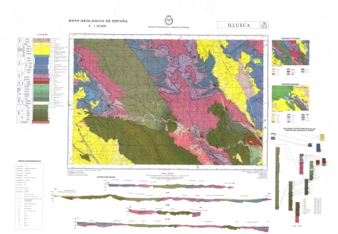
The sheet 381 (ILLUECA) of the National Geological Map (MAGNA), was made in 1981 and published in 2000 by the Geological Survey of Spain. It is distributed at scale 50000. The geological map shows the nature of materials (rocks and sediments) that appear on the surface, their spatial distribution and geometric relationships between the different cartographic units represented. A geological mapping unit is the grouping of one or more lithologies with common age range, which is represented on the map at a scale or defined resolution. Each mapping unit, and the different geological structures, is represented on the map with a symbolism itself. The representation of these units on the topographic base map provides some three-dimensional information that is completed with other geological data and geological sections, stratigraphic profiles, polls, etc. The map legend is a pictogram representing the spatial relationship of the different mapping units (chronology, overlapping, geometric relationship, lateral facies changes, etc.). It also includes structural, hydrogeological and geological location of the sheet within the regional schemes. Since 1991, the Geological Map Series MAGNA is made inseparably with the geomorphological map on the same scale. This map incorporates everything on the surface geology and provides a structured and accurate information of the land forms. It is organized on the basis of morphogenesis and morphocronology incorporated the map using the corresponding chronostratigraphic column included in a table / legend inspired by the geological map. The forms, erosional and depositional, are represented on the map by individualized by symbols and patterns of color and surface deposits or lithological formations elements that provide information. For each sheet of the series MAGNA there is an explanatory report published, edited and in digital format. The digital information is stored in coverage and Shape format (ESRI). There is a guide that describes the physical structure of the digital information and its codification.
-

The sheet 241 (ANGUIANO) of the National Geological Map (MAGNA), was made in 1990 and published in 1994 by the Geological Survey of Spain. It is distributed at scale 50000. The geological map shows the nature of materials (rocks and sediments) that appear on the surface, their spatial distribution and geometric relationships between the different cartographic units represented. A geological mapping unit is the grouping of one or more lithologies with common age range, which is represented on the map at a scale or defined resolution. Each mapping unit, and the different geological structures, is represented on the map with a symbolism itself. The representation of these units on the topographic base map provides some three-dimensional information that is completed with other geological data and geological sections, stratigraphic profiles, polls, etc. The map legend is a pictogram representing the spatial relationship of the different mapping units (chronology, overlapping, geometric relationship, lateral facies changes, etc.). It also includes structural, hydrogeological and geological location of the sheet within the regional schemes. Since 1991, the Geological Map Series MAGNA is made inseparably with the geomorphological map on the same scale. This map incorporates everything on the surface geology and provides a structured and accurate information of the land forms. It is organized on the basis of morphogenesis and morphocronology incorporated the map using the corresponding chronostratigraphic column included in a table / legend inspired by the geological map. The forms, erosional and depositional, are represented on the map by individualized by symbols and patterns of color and surface deposits or lithological formations elements that provide information. For each sheet of the series MAGNA there is an explanatory report published, edited and in digital format. The digital information is stored in coverage and Shape format (ESRI). There is a guide that describes the physical structure of the digital information and its codification.
-
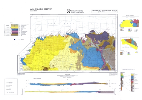
The sheet 617B (CABO DE MENORCA) of the National Geological Map (MAGNA), was published in 2003 by the Geological Survey of Spain. It is distributed at scale 50000. The geological map shows the nature of materials (rocks and sediments) that appear on the surface, their spatial distribution and geometric relationships between the different cartographic units represented. A geological mapping unit is the grouping of one or more lithologies with common age range, which is represented on the map at a scale or defined resolution. Each mapping unit, and the different geological structures, is represented on the map with a symbolism itself. The representation of these units on the topographic base map provides some three-dimensional information that is completed with other geological data and geological sections, stratigraphic profiles, polls, etc. The map legend is a pictogram representing the spatial relationship of the different mapping units (chronology, overlapping, geometric relationship, lateral facies changes, etc.). It also includes structural, hydrogeological and geological location of the sheet within the regional schemes. Since 1991, the Geological Map Series MAGNA is made inseparably with the geomorphological map on the same scale. This map incorporates everything on the surface geology and provides a structured and accurate information of the land forms. It is organized on the basis of morphogenesis and morphocronology incorporated the map using the corresponding chronostratigraphic column included in a table / legend inspired by the geological map. The forms, erosional and depositional, are represented on the map by individualized by symbols and patterns of color and surface deposits or lithological formations elements that provide information. For each sheet of the series MAGNA there is an explanatory report published, edited and in digital format. The digital information is stored in coverage and Shape format (ESRI). There is a guide that describes the physical structure of the digital information and its codification.
-
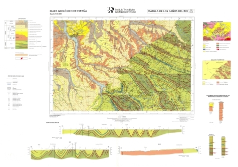
The sheet 502 (MATILLA DE LOS CAÑOS DEL RIO) of the National Geological Map (MAGNA), was made in 2000 and published in 2009 by the Geological Survey of Spain. It is distributed at scale 50000. The geological map shows the nature of materials (rocks and sediments) that appear on the surface, their spatial distribution and geometric relationships between the different cartographic units represented. A geological mapping unit is the grouping of one or more lithologies with common age range, which is represented on the map at a scale or defined resolution. Each mapping unit, and the different geological structures, is represented on the map with a symbolism itself. The representation of these units on the topographic base map provides some three-dimensional information that is completed with other geological data and geological sections, stratigraphic profiles, polls, etc. The map legend is a pictogram representing the spatial relationship of the different mapping units (chronology, overlapping, geometric relationship, lateral facies changes, etc.). It also includes structural, hydrogeological and geological location of the sheet within the regional schemes. Since 1991, the Geological Map Series MAGNA is made inseparably with the geomorphological map on the same scale. This map incorporates everything on the surface geology and provides a structured and accurate information of the land forms. It is organized on the basis of morphogenesis and morphocronology incorporated the map using the corresponding chronostratigraphic column included in a table / legend inspired by the geological map. The forms, erosional and depositional, are represented on the map by individualized by symbols and patterns of color and surface deposits or lithological formations elements that provide information. For each sheet of the series MAGNA there is an explanatory report published, edited and in digital format. The digital information is stored in coverage and Shape format (ESRI). There is a guide that describes the physical structure of the digital information and its codification.
-

The sheet 923 (CÓRDOBA) of the National Geological Map (MAGNA), was made in 1973 and published in 1994 by the Geological Survey of Spain. It is distributed at scale 50000. The geological map shows the nature of materials (rocks and sediments) that appear on the surface, their spatial distribution and geometric relationships between the different cartographic units represented. A geological mapping unit is the grouping of one or more lithologies with common age range, which is represented on the map at a scale or defined resolution. Each mapping unit, and the different geological structures, is represented on the map with a symbolism itself. The representation of these units on the topographic base map provides some three-dimensional information that is completed with other geological data and geological sections, stratigraphic profiles, polls, etc. The map legend is a pictogram representing the spatial relationship of the different mapping units (chronology, overlapping, geometric relationship, lateral facies changes, etc.). It also includes structural, hydrogeological and geological location of the sheet within the regional schemes. Since 1991, the Geological Map Series MAGNA is made inseparably with the geomorphological map on the same scale. This map incorporates everything on the surface geology and provides a structured and accurate information of the land forms. It is organized on the basis of morphogenesis and morphocronology incorporated the map using the corresponding chronostratigraphic column included in a table / legend inspired by the geological map. The forms, erosional and depositional, are represented on the map by individualized by symbols and patterns of color and surface deposits or lithological formations elements that provide information. For each sheet of the series MAGNA there is an explanatory report published, edited and in digital format. The digital information is stored in coverage and Shape format (ESRI). There is a guide that describes the physical structure of the digital information and its codification.
-
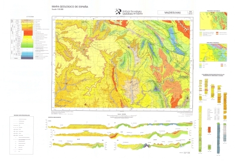
The sheet 538 (VALDEOLIVAS) of the National Geological Map (MAGNA), was made in 1989 and published in 1994 by the Geological Survey of Spain. It is distributed at scale 50000. The geological map shows the nature of materials (rocks and sediments) that appear on the surface, their spatial distribution and geometric relationships between the different cartographic units represented. A geological mapping unit is the grouping of one or more lithologies with common age range, which is represented on the map at a scale or defined resolution. Each mapping unit, and the different geological structures, is represented on the map with a symbolism itself. The representation of these units on the topographic base map provides some three-dimensional information that is completed with other geological data and geological sections, stratigraphic profiles, polls, etc. The map legend is a pictogram representing the spatial relationship of the different mapping units (chronology, overlapping, geometric relationship, lateral facies changes, etc.). It also includes structural, hydrogeological and geological location of the sheet within the regional schemes. Since 1991, the Geological Map Series MAGNA is made inseparably with the geomorphological map on the same scale. This map incorporates everything on the surface geology and provides a structured and accurate information of the land forms. It is organized on the basis of morphogenesis and morphocronology incorporated the map using the corresponding chronostratigraphic column included in a table / legend inspired by the geological map. The forms, erosional and depositional, are represented on the map by individualized by symbols and patterns of color and surface deposits or lithological formations elements that provide information. For each sheet of the series MAGNA there is an explanatory report published, edited and in digital format. The digital information is stored in coverage and Shape format (ESRI). There is a guide that describes the physical structure of the digital information and its codification.
-
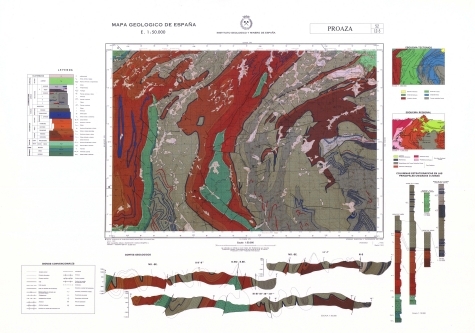
The sheet 52 (PROAZA) of the National Geological Map (MAGNA), was made in 1976 and published in 2010 by the Geological Survey of Spain. It is distributed at scale 50000. The geological map shows the nature of materials (rocks and sediments) that appear on the surface, their spatial distribution and geometric relationships between the different cartographic units represented. A geological mapping unit is the grouping of one or more lithologies with common age range, which is represented on the map at a scale or defined resolution. Each mapping unit, and the different geological structures, is represented on the map with a symbolism itself. The representation of these units on the topographic base map provides some three-dimensional information that is completed with other geological data and geological sections, stratigraphic profiles, polls, etc. The map legend is a pictogram representing the spatial relationship of the different mapping units (chronology, overlapping, geometric relationship, lateral facies changes, etc.). It also includes structural, hydrogeological and geological location of the sheet within the regional schemes. Since 1991, the Geological Map Series MAGNA is made inseparably with the geomorphological map on the same scale. This map incorporates everything on the surface geology and provides a structured and accurate information of the land forms. It is organized on the basis of morphogenesis and morphocronology incorporated the map using the corresponding chronostratigraphic column included in a table / legend inspired by the geological map. The forms, erosional and depositional, are represented on the map by individualized by symbols and patterns of color and surface deposits or lithological formations elements that provide information. For each sheet of the series MAGNA there is an explanatory report published, edited and in digital format. The digital information is stored in coverage and Shape format (ESRI). There is a guide that describes the physical structure of the digital information and its codification.
-

The sheet 309 (VILLALPANDO) of the National Geological Map (MAGNA), was made in 1981 and published in 2007 by the Geological Survey of Spain. It is distributed at scale 50000. The geological map shows the nature of materials (rocks and sediments) that appear on the surface, their spatial distribution and geometric relationships between the different cartographic units represented. A geological mapping unit is the grouping of one or more lithologies with common age range, which is represented on the map at a scale or defined resolution. Each mapping unit, and the different geological structures, is represented on the map with a symbolism itself. The representation of these units on the topographic base map provides some three-dimensional information that is completed with other geological data and geological sections, stratigraphic profiles, polls, etc. The map legend is a pictogram representing the spatial relationship of the different mapping units (chronology, overlapping, geometric relationship, lateral facies changes, etc.). It also includes structural, hydrogeological and geological location of the sheet within the regional schemes. Since 1991, the Geological Map Series MAGNA is made inseparably with the geomorphological map on the same scale. This map incorporates everything on the surface geology and provides a structured and accurate information of the land forms. It is organized on the basis of morphogenesis and morphocronology incorporated the map using the corresponding chronostratigraphic column included in a table / legend inspired by the geological map. The forms, erosional and depositional, are represented on the map by individualized by symbols and patterns of color and surface deposits or lithological formations elements that provide information. For each sheet of the series MAGNA there is an explanatory report published, edited and in digital format. The digital information is stored in coverage and Shape format (ESRI). There is a guide that describes the physical structure of the digital information and its codification.